Engaging Stakeholders Effectively and Building Sustained Capacities for the Use of Earth Observations in Strategies and Decision-Making for Land Degradation Neutrality
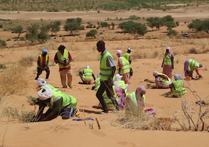
Land is an essential resource. Dramatically, land degradation – “the deterioration or loss of the productive capacity of the soils for present and future” – is happening at a growing pace worldwide, affecting more than 3.2 billion people (GEF). The loss of soil productivity is a huge threat to humans, leading to increased vulnerability to climate hazards, food insecurity, water scarcity, loss of biodiversity and ecosystem services, poverty, conflicts, migration and loss of cultural heritage (IPCC, 2019). Moreover, poor communities and vulnerable groups such as women, youth and indigenous people are often the most affected (UNCCD, 2022). Land degradation Neutrality (LDN) as “a state whereby the amount and quality of land resources necessary to support ecosystem functions and services and enhance food security remain stable or increase within specified temporal and spatial scales and ecosystems” has been recognised as the initiative that can achieve the challenge of halving land degradation (UNCCD SPI, 2016).
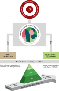 In 2015, UNCCD became the custodian agency of the UN Sustainable Development Goal (SDG) Indicator 15.3.1 on LDN: ‘proportion of land that is degraded over total land area’ which measures the target of combating desertification, restoring degraded land and soil, including land affected by desertification, drought and floods, and strives to achieve a land degradation-neutral world by 2030 (SGD 15). To scientifically support the planning, implementing and monitoring of the LDN target, the UNCCD Science-Policy Interface developed a “Scientific Conceptual Framework for Land Degradation Neutrality” (Cowie et al., 2018), which illustrates the principles and priorities to the achievement of Land Degradation Neutrality: Avoid > Reduce > Reverse. The framework is based on a counterbalancing mechanism for achieving neutrality and no net loss: anticipated losses in land-based natural capital are counterbalanced with planned gains in the same land type (UNCCD SPI, 2017).
The same year, the UNCCD Parties were invited to “formulate voluntary targets to achieve LDN in accordance with their specific national circumstances and development priorities” (UNCCD, LDN target setting). The Global Mechanism and the secretariat of the UNCCD established the LDN Target Setting Programme (LDN TSP), to support countries setting, assessing and measuring voluntary targets to achieve LDN by 2030 (UNCCD, 2019). At present, 129 countries have committed to this process, with more than 100 having already set their voluntary LDN targets. To view LDN TSP country reports and commitments visit here. The monitoring and reporting system towards LDN is based on three sub-indicators: i. trends in land cover; ii. trends in land productivity, and iii. trends in carbon stock above and below ground, necessary to quantify the proportion of land that is degraded over total land area (15.3.1). (UNCCD, 2021)
Earth observation (EO), including both remote sensing and in situ data, has increasingly been used to progress towards LDN (Giuliani et al., 2020). Firstly, EO contribute to the understanding of trends and drivers of land degradation, thereby supporting the detection of priority areas for LDN interventions. Secondly, EO-based tools can help identify suitable and effective intervention actions. Thirdly, EO supports setting and implementing targets at national level and, finally, it is helpful to monitor and report progress on LDN, and hence to demonstrate the impacts of the interventions (Leeuw et al., 2018)
 From the recognised need to expand the use of EO tools and enhance national capacities to access and use EO data, in 2018 the UNCCD invited the Group of Earth Observation (GEO) to launch the Group on Earth Observations Land Degradation Neutrality Flagship (GEO-LDN) with the aim to “develop minimum data quality standards, analytical tools and capacity building needed to strengthen land degradation monitoring and reporting, using remote sensing and data collected on site.”
PlanAdapt is supporting the GEO-LDN initiative in their global project ‘Geospatial Data for Development – Supporting the Land Degradation Neutrality Initiative of the Group on Earth Observations (GEO-LDN Initiative)’ by developing a Stakeholder Engagement Strategy with the aim to connect data providers with data users and create a community of engaged stakeholders working with earth observation data and tools to improve spatial planning for better policy and decision-making to achieve LDN. PlanAdapt’s team will develop a dynamic graphical actor map, perform a stakeholder analysis formulating recommendations to the GEO LDN on which countries to prioritise for partnership building, and eventually, will develop an ad-hoc stakeholder engagement strategy that will inform the pursued multi-level and multi-actor approach towards capacity building on EO for sustainable land use planning.
PlanAdapt is collaborating and consulting the GEO-LDN initiative by providing expertise and hands-on experience in:
- Climate knowledge brokering and stakeholder engagement in research co-creation processes
- Harnessing the power of data for climate resilience and sustainability challenges
- Data Ecosystem Mapping to plan, develop and draw visual representations of data, locations, and actors within a given ‘data ecosystem’.